

Click on the map to open the App SchweizMobile
| ITALIANO La nostra confort zone è decisamente il Ticino. Ci piace stare al sicuro tra le sue braccia, perderndoci in uno dei mille sentieri a disposizione in tutto il Cantone. Ma fa bene anche uscire dalla propria routine, esplorare luoghi nuovi. Siete d’accordo? Mi son sempre chiesta come fossero i sentieri in Italia, se fossero ben segnalati, quali paesaggi avrei potuto scoprire, come avrei fatto senza la mia applicazione sentieristica preferita, ecc. Ma nulla di più semplice. | ENGLISH Our comfort zone is definitely Ticino. We like to stay safe in his arms, losing ourselves in one of the thousand paths available throughout the Canton. But it’s also good to get out and break the routine, explore new places. Do you agree with me? I have always wondered how the paths in Italy were, if they were well marked, which landscapes I could photograph, how I could stay without my favorite pathway application, etc. But nothing simpler. |

| Per non stravolgere troppo la mia routine, ho deciso di non allontanarmi troppo dai nostri confini e sono finita in Val D’Intelvi. Avevo sentito parlare del Rifugio Venini (stessi proprietari del Rifugio San Lucio a cavallo tra Val Colla ed Italia) ma mai avrei pensato fosse così alla portata di mano. E così insieme ad un’amica, siamo partite alla scoperta del Rifugio e del Monte Galbiga! | I didn’t want to upset my routine too much, so I decided to stay close to the borders between Swiss and Italy and I ended up in Val D’Intelvi. I have heard about the Rifugio Venini (the same owners of Rifugio San Lucio between Val Colla and Italy) but I never thought it was so handy. And so together with a friend, we left to discover the Refuge and the Mount Galbiga! |

| Vi dirò che non è stato facile capire dove avremmo potuto posteggiare, da dove saremmo partite e quale sentiero avremmo intrapreso. Su una cosa eravamo certe: NIENTE NEVE! Controllando le cartine e leggendo qualche sito di trekking, siamo giunte alla conclusione che avremmo posteggiato all’Alpe di Colonno e avremmo preso la strada forestale che porta al rifugio. Tra l’altro il Rifugio è facilmente raggiungibile in automobile, fino all’Alpe di Colonno la strada è ben tenuta e pulita, dopo è un pochino ammaccata ma fattibile. | I will tell you that it wasn’t easy to understand where we could park the car, where we would start from and what path we would take. On one thing we were certain: NO SNOW! Checking the maps and reading some trekking sites, we came to the conclusion that we would park at the Alpe di Colonno and take the forest road that leads to the refuge. Among other things, the Refuge is easily reachable by car, up to the Alpe di Colonno the road is well maintained and clean, after it is a little dented but feasible. |

| Questa è una gita molto intuitiva, anche senza cartine qua e là troverete delle indicazioni. Potete comodamente seguire la strada forestale (quello che abbiamo fatto noi) oppure percorrere la cresta di montagne dall’Alpe porta al Rifugio. Anche questa via è facilissima in quanto costeggia la strada dall’alto e per un bel tratto è priva di bosco. Ho comunque il vago presentimento che sia una meta molto conosciuta. Noi abbiamo incontrato poche persone in quanto era un giorno feriale in Italia, ma occhio nei fine settimana! | This is a very intuitive hike, even without maps, here and there, you will find indications. You can easily follow the forest road (the one we did) or take the mountain ridge from the Alpe di Colonno to the refuge. This route is also very easy as it runs along the road from above and for quite a while is devoid of woods. I have the vague presentiment that it is a well-known destination. We have met few people as it was a weekday in Italy, but watch out for the weekends! |

| A tratti ammirerete le valli del Lago di Como, in altri le nostre valli ed il Ceresio. Una montagna in mezzo a due laghi stupendi con un paesaggio da cartolina! La via non è per niente faticosa ed è fattibile anche con bambini abituati a camminare, inoltre la si può fare comodamente in bici in quanto il dislivello non è eccessivo (ovviamente sto pensando alle famiglie, i giovinastri ed adulti possono anche prendere vie più impervie) 🙂 | At times you will admire the Lake Como valleys, other moments our valleys and the Lake Luganio. A mountain in the middle of two beautiful lakes with a postcard landscape! The road isn’t tiring at all and is feasible even with children that love walking, you can also do it comfortably by bike as the difference in height is not excessive (obviously I am thinking of families, young people and adults can also take tricky routes) 🙂 |

| Purtroppo abbiamo trovato il Rifugio chiuso, ma abbiamo scoperto che sono dog friendly in tutto e per tutto e le proposte culinarie ottime. Queste sono le notizie che ci piacciono! Ovviamente su prenotazione, potrete alloggiare al Rifugio con il vostro amico a 4 zampe e se beccate la data giusta, a pochi passi dal Rifugio c’è un telescopio astronomico PAURA! | Unfortunately we found the Refuge closed, but we discovered that they are very dog friendly and have excellent culinary proposals! These are the news we like the most! Obviously, by reservation, you can stay at the Refuge with your 4-legged friend and if you catch the right day, just a few steps from the Refuge there is an amazing astronomic telescope! |

| Pensate… sera limpida, tramonto fantastico, cena con una bella polenta accompagnata da un buon… fate voi cosa… e per finire, ammirare le stelle da questo telescopio! Magico… un momento magico per finire in bellezza la giornata! | Think … clear evening, fantastic sunset, dinner with a nice polenta accompanied by a good … what do you want … and finally, admire the stars from this telescope! Magical … a magical moment to finish off the day! |

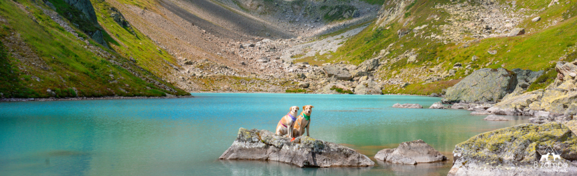
| Giusto, manca la foto in vetta al Monte Galbiga per finire l’articolo…. Eccola: | Right, the photo on the top of Monte Galbiga is missing to finish the article …. Here it is: |

| Distanza Distance | 14km / 45931,8ft |
| Tempistica Time | ca. 03h00 |
| Dislivello Difference | ca. 400m / 1312,34ft |
| Mezzi di trasporto Pubblic transportation | L’Alpe di Colonno è raggiungibile sono in automobile. C’è comunque la possibilità di prendere la Funivia da Argegno fino a Pigra (calcolare il percorso aggiuntivo) There’s no way to reach Alpe di Colonno with a public transportation but I have a solution for you. In Argegno there’s a cableway to Pigra and then start your hike from there. You just have to calculate time and km more… |
| Parcheggio Parking | Clicca qui per aprire Google Maps Click here to open Google Maps |
| Bambini Children | Secondo me, un bambino sopra i 7 anni con spirito avventuriero, può farla tranquillamente! For me a 7 yo child with a wild spirit can do it easly! |
| Acqua Water | Non presente, da portare in abbondanza soprattutto se fa caldo. Passeggiata esposta al sole. No chance to find water, bring enough, specially when is warm cause the hike is mostly under the sun. |
| Informationi Information | http://www.rifugiovenini.it/ |